
Drones and their uses
Little Things ~ Big Results
A lot of vegetation management works are being done with the help of drones. The UAVs help survey and monitor crops and vegetation change over the years.
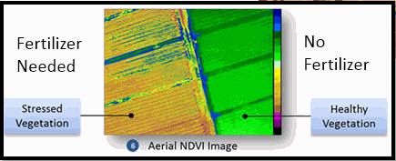
Drones have different purposes and tasks in regards to vegetation and agriculture. Some drones are used to map the location of weeds and other pests. Others are used to locate plants that need more pesticide so that farmers will not have to spray the entire farm to avoid environmental damages. They are also used to measure drought and nutrients deficiency.
Different sensors that are used to monitor agriculture and vegetation change by drones are: High-Resolution Radiometer, a Thermal Camera to monitor the temperature and the hydration of the plants, and a Laser Scanner.
Vegetation and Agriculture

Compact STS model Spectrometers are being used by researchers in New Zealand to investigate plants parameters. One sensor is deployed on the ground and the other is on board a drone to make synchronized hyperspectral measurement to help for effective crop management.
For more information:
